|
|
|
|
 |
|
|
|
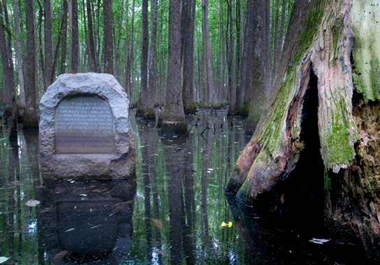
THE MONUMENT READS: This stone marks the base established Nov. 10, 1815, from which the lands of the Louisiana Purchase were surveyed by United States engineers. The first survey from this point was made to satisfy the claims of the soldiers of the War of 1812 with land bounties. Erected by the Arkansas Daughters of the American Revolution. Sponsored by the Languille Chapter. 
Sunday, June 20, 2010 Sometimes a controversy or the results thereof are not a bad thing. Such is the case with the monument above, which is where it is because of a disagreement over the exact location of a section of county line dividing Lee and Phillips counties in Arkansas. It was 1921 and officials of both counties decided a survey would resolve the disagreement. As a result, the powers that be hired two surveyors, E. P. Douglass and Tom Jacks, to venture into this fetid Delta swamp and find the exact location of the county line. In so doing, they happened across the handiwork of two previous surveyors, Prospect K. Robbins and Joseph C. Brown, who did their work in the same territory in 1815. They were plying their trade at the behest of then President of the United States, James Madison, husband of Dolly, of White House, and now, cupcake fame. President Madison commissioned Robbins and Brown to establish an initial point from which the recently acquired Louisiana Purchase would be surveyed. The idea was to find a couple of known points to establish a new one. The north-south line is called a meridian and the east-west line is called a baseline. Where the two lines cross is the new point from which surveys may be made. Robbins surveyed north from the junction of the Arkansas and Mississippi Rivers. Brown surveyed west from the mouth of the St. Francis River. Robbins and Brown did not meet at the actual point on their first pass. Brown passed the point first. On November 10, 1815, Robbins crossed Brown’s tracks and sent some of his minions to backtrack, find Brown, and bring his party back to the now discovered initial point. Their reunion happened in the neighborhood of November 24, 1815. They proceeded to hack slash marks in a couple of gum trees to mark the historic confluence of meridian and base line. Fast forward to 1921. Douglass and Jacks are slogging through the swamp when to their surprise they find the trees marked by Robbins and Brown 106 years earlier. Reportedly, Jacks’ exact words at the discovery were, "By all odds of probability, this has to be the original point for the Louisiana Purchase survey." He could not have been more right. While it is hard to be elated when standing knee deep in a swamp, I strongly suspect that's how the two intrepid surveyors felt. The L'Anguille Chapter of the Daughters of the American Revolution, not missing a chance to do something good, commissioned and installed the monument at the spot in 1926. The site is now listed on the National Register of Historic Places and is the location of the Arkansas Louisiana Purchase State Park. Visitors to the park today — unlike Robbins, Brown, Douglas, and Jacks — can visit the spot high and dry due to a well constructed and nicely maintained elevated boardwalk.  B A S E L I N E : Looking west (the monument is behind you), you can see the baseline running through the trees. Theoretically, were you to start off slogging west along this trace, you would eventually set feet on Baseline Road in south Little Rock, portions of which run along the baseline. Now you know where that sucker got its name. The significance of the starting point may be lost on most folks, but virtually every property line in all of Louisiana, Arkansas, Missouri, North Dakota, South Dakota, and Oklahoma — and the biggest parts of Kansas, Colorado, Wyoming, Montana, and Minnesota — are based on this point. Thanks to a squabble between a couple of Arkansas county judges, we know where it is.
Sources for this story:
N O T E S:
 Most of the time, there is more to the Photo of the Week story than can be told in an essay. And most of the time there are more pictures to be seen. Presuming that some folk will enjoy being privy to this trove of information, I have created a blog, “Weekly Grist for the Eyes and Mind,” where I am showing and telling “the rest of the story." There are also some blatantly commercial mentions of some of the things we do to earn our beans and taters. Click on the Weekly Grist logo and go to the blog. — J. D.
 |
|


|
|


|
|

|
|
|
|
CornDancer.com is the personal website of Dr. Freddie A. Bowles and Ebenezer Baldwin Bowles.
CornDancer has participated in the World Wide Web since 2000. Submissions are invited. Contact webmaster at threadspinner@corndancer.com |
|
|
|